↓
 

Travels with George and Marta

Journeys in the Botanical World

Travels with George and Marta
  • Home
  • About
  • Travels
    • Australia
      • Perth
      • Midwest of Western Australia
      • Kalbarri to Narrogin
      • The Great Southern Region and Albany
      • Margaret River
      • Sydney
    • Borneo
      • Kota Kinabalu
      • Nepenthes at Mesilau
      • Rafflesia at Poring Hot Springs
      • Danum – Borneo Lodge
      • Kuching
      • Bako
    • California
      • Anza Borrego – March 2006
      • Los Angeles Gardens April 2008
    • Chile
      • Chile Santiago
      • Chile Atacama
      • Chile Lake District
      • Chile Patagonia
    • Namibia
      • Waterburg and Etosha
      • Etosha and Erongo
      • Welwitschia and Sossusvlei
    • South Africa
      • Kirstenbosch Gardens
      • Bushmans Kloof – Part 1
      • Bushmans Kloof – Part 2
      • Springbok
      • Richtersveld
      • Nieuwoudtville
      • Cape Town Part 1
      • Cape Town Part 2
Home - Page 95 << 1 2 … 93 94 95 96 97 … 100 101 >>

Post navigation

← Older posts
Newer posts →

World Wide Wine Blogging Wednesday

Travels with George and Marta Posted on September 1, 2004 by MartaDecember 28, 2014

veramonte2 I don’t remember exactly where I first came across Lenndevous blog bug I’ve subscribed to it for a couple of months. Lenn proposed have a monthly blog wine tasting event similar to the monthly cooking even “Is My Blog Burning?”. My blog isn’t oriented toward food but I do enjoy drinking wine so I thought I’d grab a bottle and join in.

I wanted to select a Chilean Merlot because we recently visited Chile in December 2003. In planning for the trip, we tried several Chilean wines. I enjoyed the wines. They were always a good economical wine but I never found anything really stellar.

My wine was Veramonte 2002 Merlot Casablanca Valley. I purchased it at my local grocer, Larry’s Market, which has a good selection of wines. It was on sale at $7.99; $3.00 off the normal price of $10.99.

The tasting notes on the bottle;
“Deep berry flavors merge with a velvety smooth mouthfeel, hints of chocolate and sweet oak.”

Larry’s had a tag above the wine from Wine Enthusiast rating the wine 90. I looked it up on-line and that was the rating for the 2000 vintage. Don’t you just hate it when they promote the wine with the rating and review from a different year! The 2002 vintage is rated 86;

“Bright in the glass, with a ruby tint. The nose offers good berry fruit and some plum, while the palate is basic and pure, with mild tannins and round fruit. Quite simple yet satisfying.”

label2 The inital taste was very berry. As it opened up, I could taste more undertones of chocolate along with berry and plum. It was medium bodied with some tannins. The aroma changed throughout the evening. At one point the aroma was of cranberries and later more leather. It was interesting throughout the evening.

It went well with dinner. I had a home-made burger and G had a portabello mushroom burger with feta cheese. Oven roasted fries was the side.

I don’t particularly like Merlot. I prefer spicier reds such as a Rhone Syrah or a Zinfandel. Merlots tend to be too soft and somewhat boring to me. I did enjoy this wine and would recommend it to others who were looking for a good buy on a Merlot. I probably would not purchase it again mainly because I don’t care much for Merlot.

Posted in Wine | Leave a reply

Summit

Travels with George and Marta Posted on July 29, 2004 by MartaDecember 28, 2014

ontop

On Thursday, we got up at 2am and had a quick cup of coffee and pastry. After a 30 minute drive we were at the Whitney Portal. As we pulled into the parking lot, we saw several bears rummaging around the area. Bear canisters are required and absolutely no food can be left in the car. The bears will break in your car if they see an ice chest or smell food.

At 3:15am, we started our hike. The trail is very easy to follow. The first 2.8 miles to Lone Pine lake is well graded with not a lot of rocks or roots. As you hike, you can see other hikers ahead on the switch backs. They look like fireflies in the dark with their headlamps. After about three miles, the dawn broke and we could pack our headlamps. The time and miles seemed to fly by. At 4 miles (Mirror Lake), the hillsides turned golden as the first days of sun touched the stark white mountainsides.

switchbacks
At 8am, we reached Trail Camp, 12,040Ft 6.3 miles. From this point, we would start the 97 switchbacks up to Trail Crest at 13,660. This is the section that often bests some of the best hikers. Altitude sickness may strike at anytime at this altitude. We took a break, ate a sandwich and energy gel. We also filled up our water since this was the last water source for the next 5 (10 RT) miles. Other than a slight upset stomach, we both felt fine. The four days of acclimating paid off.

Heads down, we headed up. At places you can see other hikers above you. Don’t look up! Just focus on the trail. Along the switch backs was a wonderful flower called Sky Pilot; Polemonium Eximium. It had a wonderful scent. It took us 2 hours to climb the 2.2 miles, 1620 elevation gain to Trail Crest. Here you enter Sequoia National Park and can now see views to the west. It also becomes very windy and cold as you pass over to the west side of the crest. There was still another 2.5 miles and 900 ft or so to go. We were feeling good and right on schedule.

Shortly after noon, we made it to the top. What a rush. We had views in all directions. We hung out for about an hour talking to others and admiring the views. Nothing but blue sky.

viewfromtop Finally, we headed down. I have a bad knee and knew it would not be easy. It was not. The trail to Trail Camp is not bad. You walk over a lot of shale and have to step down quite a bit but it is pretty smooth. The knee did not like it anyway but the worse was yet to come. The area between Trail Camp and Outpost Camp is not level and very rocky. It took me a long painful time to make it down through this section. I was pretty grumpy and G convinced me to take a couple of advils and have one more energy gel. It helped some but you really do start to feel the mileage. When will the damn rocks end???

Once past Lone Pine Lake, it is very smooth and “easy” considering you have hiked 19 miles and you have been on the trail for 14 hours. We made it down shortly after 7pm. We drove back to Lone Pine, grabbed some junk food at Carl’s and crashed. 9 hours up and 6 hours down; a very respectible time especially for a couple of 50-somethings.

Whitney Picture Gallery

Posted in Mt Whitney | Leave a reply

Lone Pine

Travels with George and Marta Posted on July 28, 2004 by MartaDecember 28, 2014

bristlecone On Wednesday, we moved to Lone Pine. We needed to get up early to start the climb so we stayed the night in Lone Pine at the Best Western. We had a leisurely morning before saying good bye to Mammoth. Our stay at the Village at Mammoth was enjoyable although a little hot (no air conditioning) and noisy during the weekend.

It is only a two hour or so drive to Lone Pine. We didn’t want to do any hiking since we needed a rest day. We decided to drive up to the Ancient Bristlecone Forest. We turned off a Big Pine and started up the windy road to Westgard Pass. My brother used to live in Big Pine and drove Westgard weekly to his job in the underground nuclear testing site in Nevada. He told me about how on one trip he hit a cow and totaled his car. I could see how it could happen. There wasn’t a lot of traffic on the road.

We turned off and travelled several miles climbing higher and higher through the pinyon pines. Off to the west were views of the eastern slopes of the Sierra. It wasn’t until we reached 10,000 that we started to see those hardy survivors, the Bristlecone Pines. We spent some time in the vistor center before going on a short hike at the Schulman Grove. It was amazing to see the trees that were centuries old that are able to survive at 11,000ft.

We checked in about 3pm and rested a bit before heading out for Pizza at the Pizza Factory. We stopped and picked up some donuts for breakfast and headed back to the motel. We needed to get to bed early. I worked on a schedule. It is common for thunderstorms to gather as the day progresses. It is recommended that you summit early so you are off the mountain in the afternoon when the chance of lightening is greater. I used our guide book, reviewed the mileage and elevation. I had a good idea of our pace. If we kept a steady pace, we could probably make the summit by noon or 1pm at the latest. That would be excellent.

We finished our packing for the climb, checked and rechecked that we had everything, prepared the coffee and set the alarm. We made it to bed by 9pm and fell fast asleep.

Posted in Mt Whitney | Leave a reply

Long Lake Bishop

Travels with George and Marta Posted on July 27, 2004 by MartaDecember 28, 2014

longlake2
On Tuesday, it was time for our second high altitude conditioning hike. I really wanted to see the area around Lake Sabrina outside of Bishop. It was the one area I had never been to when I visited the area as a child. But my parents would always talk about the area up around Buttermilk. It was a longer drive from Mammoth (about 60 miles) so we debated a bit about hiking in the area instead of something closer. But curiosity won out.

It was a quick drive into Bishop. Much of Hwy 395 is four lanes so you can make good time although Hyundei slowed down going over Sherman Grade. We turned off downtown Bishop and headed back west. The road is paved all the way to the trail head at 9,800Ft. Our destination was an easy hike to Long Lake. (5 miles rt, 10,700, 900 elevation gain). This was a much more popular trailhead. A day or two hike from the TH and you can easily reach the John Muir Trail. A three or four day hike can take you to the Palasides or Emigrant Basin. But the stark beauty. You reach county like the Enchantments with just a few hours day hike.

The parking lot was very busy. There were a lot of backpackers gearing up at 10am for the three day hike. Some were just being dropped off. I suspect they had parked their cars at the destination and hired someone to transport them to South Lake.

The hike started out above the short of South Lake and then switched back up through bristlecone pines. It was pretty busy at first but we spread out after a bit. After about 1 1/2, we reached Long Lake. It was gorgeous and quite large. There were many flowers in bloom in the meadows that surrounded the lake. We decided to eat lunch and rested along the shore. It was quiet with just the occasional buzz of a bee. Fortunately, the mosquitoes were not too bad.

We decided to go a bit further. The trail skirted the edge of the lake. We passed a couple of boys fishing. At the inlet to the lake the trail started to climb and we were rewarded with some nice views back over the talus slopes. After about another hour, we decided we had done enough and headed back. It was getting hot.

Back in Bishop, we stopped at Wilson’s Eastside Sports to pick up a few last minutes supplies. It is a great store. I couldn’t resist buying a new hat.

For dinner, we decided to splurge and eat at the restaurant at Convict Lake Resort. It was the perfect way to end our stay in Mammoth. It is a short drive from Mammoth and has excellent food. The interior is cozy lodge style decor with views of the surrounding hills. It is not located lakeside as I expected but just off the road in the resort which located before you get to the lake.

We started by splitting the Louisiana Crayfish Cake. I had a Caesar Salad and G had the Spring green salad. I had a great rack of lamb. Very generous portion. G had the Ahi tuna. To drink, we had a bottle of Trefethen dry Riesling. Although tempted by the Bananas Foster that we saw being prepared at several of the tables, we passed on desserts.

A leisurely drive back to condo in the twilight. A great way to end our stay in the area.

Posted in Mt Whitney | Leave a reply

Eastern California Siteseeing

Travels with George and Marta Posted on July 26, 2004 by MartaDecember 28, 2014

Monday was a hike-free day. We did a road trip to see some of the sites in Eastern California. We started the day with a drive up to the Minaret Vista. The it was off to Hwy395. We turned off and did the loop to June Lake. So much sleepier area than Mammoth.

monolake It was on to Mono Lake. I have never seen the tufa foundations close up so we decided to go to the visitors center on the south shore of the lake. It was very interesting. There was an interpretive trail from the center to the shore. Along the way, it showed how far the lake had receded. The level of the lake is falling due to the diversion of water from the Owens Valley to LA. It was also very cool to see the brine shrimp and alkaline flies which are native. Amazing example of adaption.

Next it was off to Tioga Pass and Yosemite National Park. But first a stop at lunch. I had found the Whoa Nellie Deli on the web and just had to try it. I couldn’t believe that there would be a gourmet restaurant in a gas mart. But there was. It was actually very good. G had a grilled vegetable burger which was grilled vegetables on a bun. I had the lobster taquitos which was a bit disappointing. I didn’t expect them to also have regular taco meat in addition to bits of lobster. Plus they were deep fried and crisp. The sides were excellent. I had a ginger coleslaw and G had some excellent fries.

yosemite We drove into the park as far as Olmstead Vista above Lake Tenaya. We were actually quite disappointed in the park. It was very crowded especially around Tuolumne Meadows. Most of the trailheads were lined with cars. Olmstead Vista was nice. We had a chance to walk a short distance away and got away from the crowds. It was a little hazy because of there were two small forest fires burning between Tuolumne Meadows and the Valley but still pretty inspiring vistas.

It seemed to take no time to get back to Mammoth. We had a light dinner in the condo and then went out for a drive around the Mammoth lake area and watched the sun turn the mountains a golden hue.

Posted in Mt Whitney | Leave a reply

Mono Pass

Travels with George and Marta Posted on July 25, 2004 by MartaDecember 28, 2014

littlelake
Our first training hike was Mono Pass out of Rock Creek. From Mammoth, we drove about 30 miles to the trail head at Rock Creek and 10,300 ft. The road is paved all they way and there is no charge to park at the trail head at Mosquito Valley. The trail head has a clean modern restroom (fully stocked with toilet paper) and adequate parking. I didn’t need a trail pass or have to pay anything to park and do a day hike. This is quite different from hiking in Washington State where you pay $30.00 per year to park at the trailheads.

The trailhead is for two hikes, Little Lakes Valley and Mono Pass. The trail goes about ½ mile then splits. We took the right fork and headed up to Mono Pass. The flowers were spectacular. The end of July is a perfect time for wildflowers. Around the lakes, there were mosquitoes but not too bad.

monopass After we passed the junction to Ruby Lake, we got above both the tree line. We were passed several times by horse parties and mule packs out of Rock Creek. It is so dry at this altitude that there were few flies and the horseshit dried quickly. The mule urine was a bit smelly (like a barnyard) but much easier to take than Teanaway. It was very desolate but the views back down to Little Lakes were spectacular.

After 4 miles, we had climbed to the pass at 12,040. Breathing was a bit labored and we had a headache. Lunch time. We then climbed to the ridge and had a stunning view down to Pioneer Basin.

On the way down, we saw a bunch of runners. A SoCa high school track team was training. It was actually fun and inspiring to share the trail with the teenagers. But it was better back at the condo for a hot bath and beer.

Posted in Mt Whitney

The Journey Begins

Travels with George and Marta Posted on July 24, 2004 by MartaDecember 28, 2014

alabamahills

We left today and flew to Ontario CA. The plane flew along the eastern slope of the Cascades. We thought we had scored and would be able to see Whitney. Not so lucky! The plane crossed over the Sierras between Tahoe and Yosemite and ended up approaching Ontario from the Central Valley. We did get a great view of the Yosemite Valley.

We picked up our compact (slow climbing hills) Hyundai and headed north. Gosh, is it a power-less wonder. We traveled over Cajon Pass in the shadow of Mt. Baldy and quickly got a taste for the fast driving in CA. Now I know why SUVs sell so well. While we were in the truck lane, SUV after SUV passed us at 75 MPH. The Hyundai struggled along at 60mph.

PortalroadAfter a quick stop at In-N-Out burger in Hesperia, we crossed the Mojave Desert. Nothing but heat for miles. How did people drive across without AC? I remember traveling once with my parents from Pasadena. We crossed the area at night to avoid the heat. You could feel it through the car roof and floor. But slowly in the distance we could see the Sierras!

After about 3 hours, we reached Lone Pine. We still had a couple of hours left to drive before reaching Mammoth Lakes for four days to acclimate. We decided to go ahead and drive up to the Portal so we would know where the trailhead and parking were located. It took us about 30 minutes to drive up even at the slow pace. What gorgeous views from the road.

We finally reached Mammoth after 5pm after about a 5 hour drive (300 miles). We checked into our condo and headed for the grocery store and then pizza and beer.

Posted in Mt Whitney | Leave a reply

Final plans

Travels with George and Marta Posted on July 19, 2004 by MartaNovember 24, 2014

Just a few days left before we leave. I spent the weekend doing the final research looking for restaurant recommendations and potential day trips. We will arrive early in the morning in Ontario so we will need to eat lunch pretty soon. I had my map of California and used Chowhound to search on towns we would be passing through on the drive up. It is about 200 miles to Lone pine and 300 to Mammoth. There is not much inbetween. So far, I’ve found the In-N-Out Burger in Victorville and a Mexican restaurant in Ridgecrest. I just searched a bit on the web to see if In-N-Out has some type of veggie burger. Nope. But I did find this interesting blog article on ordering burgerless hamburgers in the In-N-Out. Basically the equivalent of a grilled cheese. Hmmm… I bet it is going to be mexican food for us.

There will be a lot of choices in Mammoth. We are planning one meal at Convict Lake Resort which should be nice. If do a day trip to Mono Lake, I want to stop at Whoa Nellie Deli. It’s in a gas station in Lee Vining but has rave reviews including a mention in the NYT.

We plan to do a two day hikes and maybe a day trip. On our list of potential items to see are
– Alabama Hills
– Bristlecone Pines in the White Mountains
– Mono Lake
– Tioga Pass area of Yosemite
– Lakes around Mammoth
– Bishop

The days are going to fly by. I’m hoping that it will interest us enough to return again.

Posted in Mt Whitney | Leave a reply

Kendall Katwalk

Travels with George and Marta Posted on July 16, 2004 by MartaDecember 28, 2014

katwalk2
A Katwalk. The trail name has always intrigued us but in the past it was just a little too far (12 miles RT) for us to do in a day hike. Well, not any more.

So Kendall Katwalk was our final training hike in the NW. It is located on the PCT and starts at Snoqualmie Pass. That would be much easier and shorter to access than the recent Teanaway hikes.

We left around 8 and made it to the trail head by 9am. There were a couple of other people who were just heading out also. Boots on, grab the poles and we were off.

The trail was in the forest and started a moderate climb. It would be about 2 3/4 miles until the trail for Commonwealth Basin junction and the start of a long steady switch back up Kendall Peak. The trail was pretty smooth, just a few rocks and roots so I started with a fast pace. We passed a couple of backpackers both going and coming and just within a hour we were at the junction. We’ll need a slower pace for Whitney.

The trail now starts a very long and steady switchback. I didn’t find it too bad and soon we were near the top and the views were opening out to Red top and Commonwealth Basin. The forest opened up and we were walking through Kendall Gardens with lovely wildflowers of paintbrush, lupine, valerian and aster. The day was also warming up.

katwalk3
About 11:30 we reached the start of the Katwalk. We decided to lunch. The Katwalk itself was kinda disappointing. It is pretty amazing to see the trail blasted out of rock and the views were stunning. But it was very short. We took many pictures and then decided to continue on across heather fields and talus rocks to the next ridge. By this time it was 1pm and we had probably gone about 6-7 miles. Time to head back.

My muscles stiffened a bit with the downhill and it was so hot. The upper part of the trail is exposed and it was great to reach the forest. We pass the junction and started noticing the area near the pass. At first we thought we were looking at parking lot at the pass but realized it was really fully stopped traffic on I-90. Another accident. That was the second Friday in a row. We asked a hiker on the way up and the accident had occured 12 miles east of the pass. They were only let one lane through while they investigated the accident. We were glad we going west.

Shortly before 4pm, we reached the parking lot. It felt great to get the boots off. We headed for North Bend for a couple of burgers at Scotty and home.

Mileage: 14 miles Elevation: 2700ft Time: 7 hours

Posted in Mt Whitney | Leave a reply

Iron Peak – Ingalls Loop

Travels with George and Marta Posted on July 9, 2004 by MartaDecember 28, 2014

teanaway2
We needed to test ourselves on yet a longer hike. Whitney is 22 miles so the more we do long hikes, the better prepared we will be for the distance. I looked through the Loop Hikes book and saw an interesting hike starting at Iron Peak, dropping down to Beverly and then looping over to Ingalls Creek. We’d come back up Fourth Creek to Beverly and back over Iron. A nice 16.5 mile trip with an elevation gain of around 4500ft.

There was the potential issue of crossing Ingalls Creek twice. It is really swift and deep where we typically hike and I wasn’t certain what it would be like to cross. I asked on the hiking board and got mixed answers but most felt it would be fine to cross. It would probably be somewhere around calf high so we decided to take some sandals to cross in.

We planned to leave Seattle by 7am but didn’t leave until 7:30am which got us to the Iron Peak #1399 trailhead at 10am. We had followed another car for the last few miles and he just happened to be headed to the same trailhead. We talked a bit and he said he was only going a short ways up and headed off while we put on the boots. The weather was partially cloudy and cool with a slight breeze.

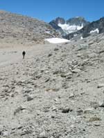
Iron Peak trail is in good condition without a lot of horse dung on the trail. It starts the climb right off making wide switch backs which take you up out of the forest and across the serpentine slopes. I was struggling a bit. I didn’t sleep much that night stressing a bit about the distance. I knew we needed to keep a 2 mph pace if we were going to do it.

At three miles you reach a saddle below Iron Peak at 6100ft. I checked the time. 11:30! Boy did that cheer me up. I thought I was going really slow but I was actually right on pace. The views are gorgeous in all directions. There are a few flowers still blooming at the saddle. There are a couple nice patches of anemone and douglasis. But no time to dally like we normally do.

The trail descends in .5 miles to the junction with Beverly-Turnpike trail # 1391 at 5600ft. Along the streams we crossed were still many flowers; shooting star, phantom orchids and elephant heads. We headed up Turnpike to another saddle with views back to Iron Peak and down Beverly. The trail started down and was very rocky. It didn’t look like it was much used even by horse groups. Much of it was down through rocky trenches and we treaded lightly so we didn’t twist an ankle but it was easy to follow. It was much better than that last bit going to Lake Bianca. In front was a full view of Mt. Stuart and the upper Ingalls valley. We heard Turnpike creek a long time before we finally crossed it and then continued on for a bit before we came to Ingalls Creek. There was a large log right at the creek so it was an easy crossing. It was shortly after 1pm so we paused to eat our lunch.

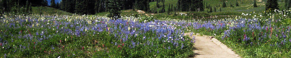
It was still about ¼ mile or so until the junction with Ingalls Creek trail. Here is a large open meadow filled with lupine that is just starting to fade and a 360 degree valley view. We headed east. The plants were about waist high and pretty thick across the trail. The trail left the meadow and entered woods. There were several small stream crossings and lots of water. At 1 ½ miles we reached the junction with Fourth Creek # 1218. It was the halfway point at 8 miles and it was 2:30. Not bad so far.

CrossingIngall2
The next crossing of Ingalls was pretty straightforward. We didn’t see any logs and the water was above the stones so, we took our boots off to cross. The water was to our calves and cold. Fourth Creek trail didn’t look like it was used much either but the trail is pretty obvious and easy to follow. It climbed up right away providing views back over the Stuart Range and then leveled a bit. It followed Fourth creek all the way with small pockets of flowers next to the creeks that feed into it. We crossed Fourth Creek and stopped to filter some water and fill our water bottles. A few mosquitos found us while we we were filtering. Surprisingly we weren’t bothered much with bugs along the way and only had a few bites when we got home.

The trail passes along the edge of a large meadow filled with flowers. Gradually we climbed up and the views opened back to the Stuart Range. Soon we were at the saddle and then dropped down a ½ mile of rocky steep trail to rejoin Beverly-Turnpike #1391. Just over 4 miles left, but first we needed to climb about 1000ft back up to the saddle near Iron Peak. By now the sun was low as we climbed up the serpentine slope. We heard a few voices from a party up on Iron Peak. It was the first people we had seen since we left in the morning. At the saddle, we noticed the clouds had thickened and darkened over Esmeralda but didn’t see any rain. I sucked down an energy gel for one last burst. Shortly after 5pm we headed down. My thighs definitely were sore but I didn’t feel too bad. We made the car around 6:15. We hit the Burger King in Cle Elum before heading back on I-90. There was an accident before the pass which had the right lane close and traffic crawled. Shortly before 10pm we pulled in the driveway. Finally, time for a beer.

Mileage: 16.5 miles Elevation: 4400ft total Time: 10.5 hours Bugs: not bad yet

Posted in Mt Whitney | Tagged Hiking, Teanaway | Leave a reply

Post navigation

← Older posts
Newer posts →

Recent Posts

  • February 2018 weather wrapup
  • Early Spring Blooms
  • Winter 2018 – Arboretum
  • Vegetable Garden 2017 #5
  • Vegetable Garden 2017 #4

Tags

"Institut de Francais" AsianCooking Australia BigIsland Birds Borneo BorneoJournal Breakfast California CaliforniaRoadtrip Camping Carnivorous Cooking Dessert EasternOregon Edmonds Fall FallMountain France Gardening Gardening Spring Hawaii Hiking Maui Memoirs NaBloPoMo Nursery Oahu Oregon Photohunt SanDiego Seattle SeattleGardens Soups Spring SSB Teanaway Tucson Turkey UrbanHike VegetableGarden VegetarianCooking Washington Wildflowers Winter

Archives

Categories

  • Africa
  • Australia
  • Borneo
  • California
  • Chile
  • Cooking
  • France
  • Gardening
  • Hawaii
  • Hiking
  • Local Sights
  • Madagascar
  • Memoirs
  • Miscellaneous
  • Mt Whitney
  • Netherlands
  • Oregon
  • Pacific Northwest
  • Seattle
  • Spring Travel
  • Travel
  • Turkey
  • Uncategorized
  • Wine
©2025 - Travels with George and Marta - Weaver Xtreme Theme
↑